HAVANA, Cuba — June 19, 2026 : Cuba has completed construction of a major signals intelligence antenna array at its Bejucal facility near Havana, significantly enhancing its ability to monitor and locate radio transmissions across a large portion of the Western Hemisphere, according to a report released on June 18, 2026, by the Center for Strategic and International Studies (CSIS).
Located approximately 145 kilometers (90 miles) from the Florida coast, the Bejucal site is now assessed as highly likely operational. The upgraded facility is capable of intercepting and geolocating communications across the southeastern United States, the Gulf of Mexico, the Caribbean, and portions of the Western Atlantic.
The development comes as the United States increases its strategic focus on the Western Hemisphere and raises concerns about foreign intelligence activities operating from Cuban territory.
Large Circular Antenna Array Completed
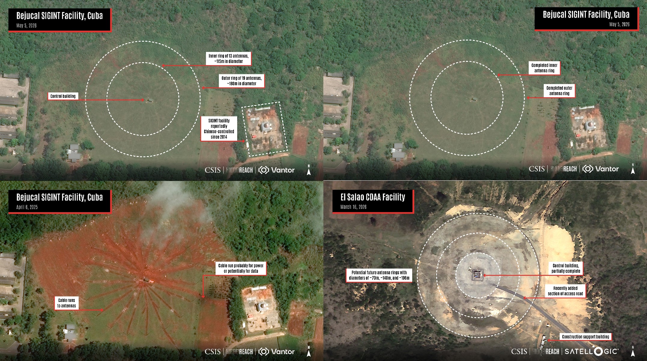
Satellite imagery analyzed by CSIS researchers Matthew Funaiole, Brian Hart, Joseph Bermudez Jr., and Aidan Powers-Riggs shows that Bejucal has undergone a major transformation over the past two years. An older linear antenna grid has been replaced with a Circularly Disposed Antenna Array (CDAA), a specialized system designed to determine the direction and origin of radio signals.
The newly completed array measures approximately 175 meters in diameter and consists of 32 antennas arranged in two concentric rings, including 19 antennas on the outer ring and 13 on the inner ring.
According to CSIS, this is the largest and most capable Cuban CDAA installation documented to date. The new system also replaces a smaller circular array previously located nearby, making Bejucal the country's most significant active signals intelligence facility.
How the System Works
A CDAA functions by simultaneously receiving radio transmissions across multiple antennas and calculating the direction from which the signal originates. By combining data from different locations, operators can accurately triangulate the source of transmissions.
The technology has roots in Cold War-era intelligence systems such as the U.S. military's Pusher and Wullenweber programs but remains relevant for modern intelligence gathering. CDAAs can be used to monitor military communications, electronic emissions, maritime traffic, and aircraft movements over distances that can range from 3,000 to 8,000 nautical miles depending on signal conditions.
Due to its location near Havana, the Bejucal facility is well positioned to observe U.S. naval operations in the Caribbean, military aviation activity across the southeastern United States, and shipping traffic throughout the Gulf of Mexico.
Suspected Links to Chinese Intelligence Operations
The Bejucal complex occupies a historically significant military site. The surrounding area was previously used during the 1962 Cuban Missile Crisis, when Soviet nuclear weapons were stationed in Cuba.
In recent years, the facility has frequently appeared in public reporting, congressional testimony, and official U.S. statements regarding foreign intelligence activities in Cuba. While CSIS notes that there is no declassified public evidence proving direct Chinese operation of the specific antenna array, U.S. officials have acknowledged that China operates at least three intelligence facilities in Cuba.
Based on official statements, construction patterns, and previous assessments, CSIS researchers believe Bejucal is likely one of those locations. However, the exact operational arrangements and level of foreign involvement remain undisclosed.
Construction Slows at El Salao Facility
The CSIS report also examined a second suspected CDAA site located at El Salao, near Santiago de Cuba on the island's eastern coast.
The location is strategically important because it lies only a short distance from the U.S. Naval Station at Guantanamo Bay. Construction activity at El Salao began in 2021, and early development included a central control building, utility infrastructure, and foundations for an inner ring of 16 planned antennas.
However, updated satellite imagery from May 2026 indicates that work has slowed significantly. No antennas have been installed, and vegetation has begun reclaiming previously cleared construction areas, suggesting that activity has been largely inactive for an extended period.
Despite the slowdown, analysts do not believe the project has been abandoned. Recent imagery shows that an access road has been repaved and redirected toward the center of the facility. Researchers note that a road crossing the center of an operational CDAA would interfere with its function, leaving the site's ultimate purpose uncertain.
CSIS stated that El Salao could eventually be completed as a modified listening post or repurposed for another intelligence-related role.
Potential Combined Coverage
If the El Salao facility is completed in the future, it could operate alongside Bejucal to provide broader intelligence coverage across the Caribbean and Central America.
Working together, the two sites could improve the ability to triangulate signals across a much larger area, including portions of the Western Atlantic, Central America, and the southeastern Caribbean. Multiple listening stations operating in coordination can increase the accuracy of signal location and tracking.
U.S. Response and Strategic Implications
The expansion of Cuba's intelligence infrastructure has already influenced U.S. policy. In a May 2026 executive order, the Trump administration imposed additional sanctions on Cuba and cited the country's hosting of "foreign adversary facilities" targeting sensitive U.S. national security information.
The developments occur amid broader geopolitical competition and growing attention to intelligence activities in the Western Hemisphere. Cuba's proximity to the United States has long made the island strategically valuable for signals intelligence collection, and the completion of the Bejucal array reinforces its role in regional surveillance operations.
CSIS emphasized that its findings are based on commercial satellite imagery and open-source analysis. While the imagery confirms the completion of the antenna array and ongoing developments at both locations, it does not provide direct evidence regarding day-to-day operations or specific operators of the facilities.
The organization stated that it will continue monitoring the sites through its Hidden Reach initiative, which tracks strategic infrastructure and intelligence-related developments using publicly available imagery and analysis.
——— End of Article ———