US Marines Install G/ATOR Radar in Tobago For Surveillance Over Southern Caribbean and Venezuela
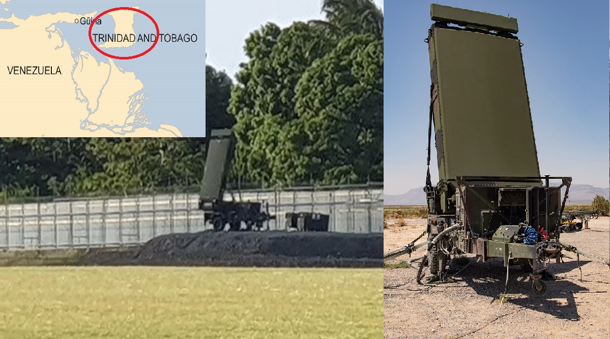
In a development that has quickly moved from technical upgrade to geopolitical flashpoint, Trinidad and Tobago’s Prime Minister confirmed on November 28, 2025, that U.S. Marines are in Tobago installing a new radar system at ANR Robinson International Airport. The admission came after weeks of mixed government messaging, during which officials repeatedly denied that American troops were active in the country. The confirmation, first reported by the Trinidad and Tobago Guardian, has intensified debate across the Caribbean about the real purpose of the deployment.
While Port of Spain frames the move as an “airport infrastructure upgrade” and a boost to surveillance against narcotics traffickers, evidence from open-source imagery and flight-tracking strongly indicates that the radar being installed is the AN/TPS-80 Ground/Air Task Oriented Radar (G/ATOR) — one of the U.S. Marine Corps’ most advanced multi-mission sensors. Its presence on the western tip of Tobago effectively extends high-resolution U.S. airspace monitoring to within sight of the Venezuelan coast, a reality not lost on regional analysts.
A High-End Radar With Capabilities Far Beyond Drug Interdiction
The AN/TPS-80 G/ATOR is a mobile, active electronically scanned array (AESA) radar developed to replace several older Marine Corps systems. Combining air surveillance, missile tracking, artillery detection, and expeditionary air-traffic control, it provides:
-
360-degree, four-dimensional coverage
-
Tracking of aircraft, cruise missiles, small drones, and even rockets and mortars
-
A detection range of over 160 km, depending on altitude and target type
-
Rapid deployment in under one hour, with mobility allowing repositioning or extraction via C-130 transport aircraft
When installed in western Tobago, much of the airspace above the Gulf of Paria, eastern Caribbean, and even approaches to Venezuela’s mainland fall within its surveillance envelope.
Additional G/ATOR capabilities include the ability to function as part of a networked sensor grid, feeding data into U.S. and allied command-and-control systems. In exercises across the Pacific, G/ATOR has already been demonstrated as a key sensor for integrated air and missile defense — an indication that its Caribbean deployment may serve more than a single mission.
Why Tobago Matters: A Strategic Window Into the Southern Caribbean
Tobago’s geography gives the island an exceptionally advantageous position for regional surveillance. Its location allows monitoring of low-flying aircraft used by narcotics traffickers, as well as drones and ultralight aircraft that often slip across maritime boundaries to evade detection. The waters around Tobago are also prime corridors for go-fast boats moving through the Caribbean shipping lanes, making the island an ideal vantage point for tracking fast, evasive smuggling vessels. In addition, Tobago sits close to key zones of Venezuelan air activity, particularly around Paraguaná and the Gulf of Paria, and provides a clear view of maritime traffic heading toward Trinidad’s energy infrastructure, including offshore gas platforms.
Although the Trinidad and Tobago government maintains that the radar’s purpose is focused on counter-narcotics operations, its advanced sensor capabilities naturally extend into strategic surveillance. The same system can detect and track military flights, missile tests, or irregular troop movements originating from Venezuela — missions that U.S. Southern Command has increasingly prioritised in recent years.
The deployment of G/ATOR in Tobago forms part of a broader shift in U.S. military posture across the Caribbean. Washington has recently expanded access agreements with the Dominican Republic, revived activity at the Roosevelt Roads Naval Station in Puerto Rico, and increased the deployment of P-8 maritime patrol aircraft, Coast Guard cutters, and AWACS missions throughout the region. The United States has also expanded its authority to carry out lethal counter-drug interdictions, signalling a more assertive operational approach in regional air and maritime spaces.
Taken together, these developments indicate that placing the radar in Tobago supports a wider U.S. plan to build an interconnected surveillance network across the Caribbean. While officially framed as a counter-narcotics initiative, the system’s positioning and capabilities make it equally suited for monitoring state actors, shaping regional dynamics, and reinforcing the strategic balance in the southern Caribbean.
Domestic Reactions: Questions Over Sovereignty and Control
The deployment has sparked unease among local security experts. The former head of Trinidad and Tobago’s National Coastal Radar Surveillance Centre publicly questioned:
-
Whether a foreign military should control a radar of this sophistication
-
Why U.S. systems are needed when the country already operates an Israeli-built coastal radar network covering much of its maritime domain
-
Whether the data from G/ATOR will be shared transparently with national authorities
Government officials argue that the radar is part of a wider upgrade that includes roads, airfield security, and border intelligence systems, linked to countering narco-trafficking, arms smuggling, and human trafficking. In recent meetings with U.S. defense officials, Port of Spain emphasized its vulnerability to transnational organized crime and portrayed Tobago as a natural hub for joint operations.
Still, the optics are sensitive: the presence of U.S. Marines on Trinidadian soil is unprecedented in recent years, and critics fear a gradual shift toward dependency or informal basing.
Regional Implications: A New Factor in the Caribbean Balance
For Venezuela — already wary of U.S. activity in the Caribbean — the installation of an American multi-mission radar less than 70 km away is likely to be seen as a forward-deployed sensor node rather than a policing tool. Analysts note that G/ATOR’s data can be fused with:
-
U.S. Navy Aegis radar networks
-
E-3 AWACS aircraft
-
Maritime patrol aircraft operating out of Curaçao, Aruba, and Puerto Rico
-
Coast Guard interdiction platforms in the Caribbean Sea
Combined, this creates a dense, near-continuous surveillance blanket over the region — useful not only for detecting smuggling but also for monitoring Venezuelan military aviation, missile developments, or maritime deployments.
Several Caribbean governments are watching closely, aware that while U.S. assistance can deter criminal networks, it can also reshape regional alignments, heighten tensions with Caracas, or invite geopolitical competition.
More Than an Airport Upgrade
The presence of a G/ATOR system in Tobago marks a significant deepening of U.S.–Trinidad and Tobago security ties. It also raises unresolved questions:
-
Who controls the radar feed?
-
Is the deployment temporary or open-ended?
-
Will the system remain if political tensions with Venezuela rise?
-
How will data-sharing be structured to preserve Trinidad and Tobago’s sovereignty?
Ultimately, the radar is not simply a sensor — it is a symbol of the country’s evolving place in a region increasingly shaped by great-power competition, transnational crime, and strategic realignment.
Whether citizens eventually view the installation as a protective shield, a geopolitical risk, or an uncomfortable concession to a powerful partner will depend on how openly the government manages the partnership and how clearly limits are defined.
But for now, Tobago has found itself at the center of one of the Caribbean’s most consequential security developments in years, with implications that extend far beyond the perimeter of ANR Robinson International Airport.
✍️ This article is written by the team of The Defense News.