Scientific Systems develops non-GPS navigation for GPS-denied environments
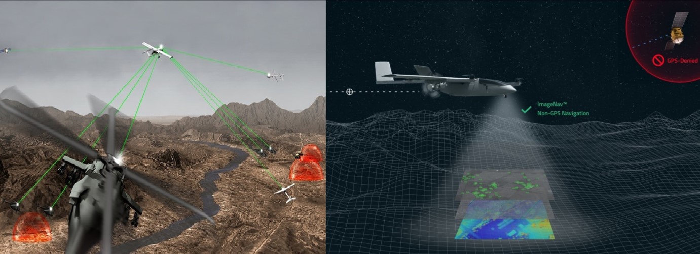
Defense News ,Europe :- Scientific Systems is making strides in the development of ImageNav, a cutting-edge non-GPS, image-based navigation software. This revolutionary technology has recently been showcased in various flight operations, ranging from high altitudes of 25,000 feet down to as low as 200 feet. Over the past decade, ImageNav has seen significant progress, backed by funding exceeding USD 45 million.
In the world of air vehicle flights, the military heavily relies on the Global Positioning System (GPS) for navigation. However, this poses a risk in contested environments, where electronic jamming can compromise GPS signals. Recent reports highlight how Russia's enhanced electronic warfare capabilities have disabled advanced US-provided missiles in Ukraine by interfering with their GPS coordinates.
ImageNav steps in as a game-changer by providing precise navigation without depending on GPS. Its applications span across various systems, including weapons, aircraft, and uncrewed aircraft systems (UAS).
The software employs three distinct algorithms to compute both absolute and relative navigation position updates. First is the stereo terrain correlation, which gathers overlapping images from a flight path using an onboard electro-optical (EO) or infrared (IR) digital camera. To determine precise geo-location, absolute position fixes are computed by correlating stereo elevation models from captured imagery with stored terrain references. The second algorithm, image-based feature matching, compares image features in captured imagery with stored image references. The third, feature-based velocity estimation, tracks image features from frame to frame, controlling inertial navigation drift between position updates. ImageNav utilizes all three algorithms simultaneously, creating a robust, GPS-like position that remains immune to jamming.
A notable feature of ImageNav is its "at-the-edge" operation, requiring minimal size, weight, and power. It seamlessly integrates into air platforms with existing sensors and processors, offering flexibility as a software-only upgrade, on a stand-alone processor board, or as a self-contained hardware payload, including a camera, processor, and inertial measurement unit (IMU).
Tom Frost, Senior VP of the Products Division at Scientific Systems, expressed the innovation of ImageNav, stating, “ImageNav is an innovative, compact solution that helps air vehicles generate accurate position fixes in the most challenging environments. Recent reports of successful efforts to jam weapons and aircraft that rely on GPS underscore the immediate need to develop a reliable non-GPS guidance system.”
Scientific Systems is actively working on integrating ImageNav into GPS-guided munitions and UASs, allowing them to operate seamlessly in GPS-denied environments. A recent live weapon drop test showcased ImageNav's capability to navigate a weapon during flight without relying on GPS, ensuring it hits the target within the required performance envelope.
✍️ This article is written by the team of The Defense News.