Poland, Denmark Launch Joint Mission to Build High-Resolution Satellite to Map Moon’s South Pole
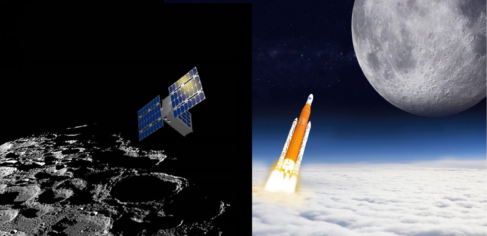
Poland and Denmark are joining forces on an ambitious lunar mission that aims to create the most detailed map yet of the Moon’s south pole, using a new satellite capable of imaging the surface at a resolution of around 20 cm per pixel. The planned spacecraft, known as Máni, is a Danish-led mission with Polish industrial and scientific partners and has been submitted to the European Space Agency (ESA) under its Terrae Novae Small Lunar Missions programme.
If ESA gives final approval, the mission would be launched toward the end of this decade, with the satellite operating from a low polar orbit about 50 kilometres above the lunar surface.
A European Moon Mapper Named Máni
Máni – named after the personification of the Moon in Norse mythology – is being developed as a roughly 210-kilogram hybrid-propulsion lunar orbiter based on Danish company Space Inventor’s Micro 24 platform. The mission is led scientifically by the University of Copenhagen, with key Danish partners including Aarhus University, the Technical University of Denmark (DTU) and the Danish Meteorological Institute, alongside a scientist from the Institute of Geological Sciences of the Polish Academy of Sciences.
On the industrial side, Space Inventor will build the spacecraft in Aalborg, while Scanway Space of Poland is responsible for an advanced optical payload and image-processing capabilities, extending its growing role in European lunar and imaging programmes.
Danish officials have framed Máni as a strategic step change for their national space sector. Copenhagen has already earmarked roughly 125–130 million Danish kroner in national funding to support the mission, signalling political backing ahead of ESA’s final funding decision by its Program Board for Human and Robotic Exploration.
How the Satellite Will Map the South Pole
Máni’s defining feature is its ultra-high-resolution imaging of the lunar south pole, with a planned ground sampling distance of up to 20 cm per pixel from a low circular polar orbit. That level of detail would allow mission teams to identify individual boulders, small craters, and subtle elevation changes across potential landing and rover-traverse sites.
Instead of taking single snapshots, the mission will use a multi-angle photometric mapping technique. The orbiter will repeatedly image the same terrain under different lighting conditions as the Sun’s angle changes over time. By combining these overlapping views, scientists can reconstruct highly accurate 3D models of the surface – effectively reading the micro-texture of the regolith down to micrometre scales, far below the nominal pixel size.
The scientific and exploration goals include:
-
Building precise 3D elevation models of landing zones, showing slopes, roughness and small-scale hazards relevant to lander safety and rover mobility.
-
Mapping boulder fields and crater distributions to assess how safe or dangerous different areas might be for future human and robotic missions.
-
Studying the physical properties of lunar soil – grain size, cohesion, and mechanical strength – to better understand how regolith behaves under wheels, landing plumes and construction activity.
-
Searching for lava tube entrances and other geological structures that could one day serve as natural shelters for lunar bases.
-
Supporting navigation and hazard avoidance systems for upcoming Artemis and ESA Argonaut landers by providing detailed reference maps.
Máni will also feed into broader Earth and climate research. By observing how sunlight reflects off the lunar surface, the mission can contribute to Earth albedo studies, which analyse how much solar radiation the Earth-Moon system reflects back into space.
Why the Lunar South Pole Matters
The Moon’s south polar region has become the prime target for the next era of exploration because of its unique combination of near-permanent sunlight on ridgelines and permanently shadowed craters that are believed to trap water ice and other volatiles. Missions such as NASA’s Lunar Reconnaissance Orbiter (LRO) and various radar and neutron instruments have already produced strong evidence that craters like Shackleton may contain significant deposits of ice, preserved in the extreme cold of regions that never see direct sunlight.
LRO has mapped nearly the entire Moon at resolutions down to around half a metre in some areas, but the polar regions – especially the darkest interiors of craters – remain challenging to image at consistently high resolution.
Máni is designed to push well beyond existing optical mapping, offering dedicated coverage of the south polar terrain at 20 cm per pixel and using techniques optimised for low-Sun conditions. The resulting dataset is expected to become a reference for:
-
Planning astronaut traverses and robotic exploration in support of NASA’s Artemis program and ESA’s own missions.
-
Locating safe landing ellipses close to potential ice deposits.
-
Informing engineering studies for in-situ resource utilisation, such as mining and processing lunar water for life support and fuel.
A Milestone for Polish and Danish Space Industries
For Denmark, Máni would be the country’s first dedicated lunar satellite and a flagship demonstration that it can lead complex deep-space missions, not just contribute instruments to international projects. The mission has already sparked academic and industrial collaboration, including workshops on trajectory design and ESA’s GODOT astrodynamics software, aimed at building national expertise in lunar mission planning.
For Poland, the project builds on the rapid expansion of its space sector. Polish company Scanway Space has become a recognised supplier of optical instruments for micro- and nanosatellites, and is already involved in several lunar-related efforts, including imaging systems for commercial lunar orbiters and other ESA small-mission concepts. Máni gives Polish engineers and scientists a central role in processing and exploiting some of the most detailed lunar data ever collected.
The collaboration also complements Poland’s investments in Earth-observation satellites and its growing participation in ESA programmes, while offering Denmark a high-profile mission that showcases its Micro 24 satellite platform and deepens its role in European exploration.
What Happens Next
Máni has completed early feasibility and pre-Phase A studies and is now awaiting a formal ESA funding decision. If approved, full Phase A/B design work would begin, leading to detailed engineering, payload qualification and mission integration. Current planning points to a launch toward the late 2020s, likely on a European-backed launcher, with operations in a low polar orbit lasting at least several years.
If it proceeds as planned, the joint Polish–Danish mission would give Europe one of the world’s most powerful tools for understanding – and eventually settling – the Moon’s south pole, delivering maps detailed enough to guide the first permanent human footholds beyond Earth.
About the Author
Aditya Kumar:
Defense & Geopolitics Analyst
Aditya Kumar tracks military developments in South Asia, specializing in Indian missile technology and naval strategy.