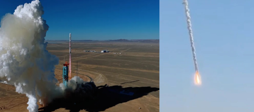
NASA-ISRO’s $1.5 Billion NISAR Mission Set for July 30 Launch on GSLV-F16

The NASA-ISRO Synthetic Aperture Radar (NISAR) satellite is scheduled for launch on July 30, 2025, at 5:40 PM IST aboard India’s GSLV-F16 rocket from the Satish Dhawan Space Centre (SDSC), Sriharikota. With a staggering mission cost of $1.5 billion (approx. ₹12,500 crore), NISAR will be the most expensive Earth observation satellite ever launched.
Jointly developed by the National Aeronautics and Space Administration (NASA) and the Indian Space Research Organisation (ISRO), NISAR is poised to revolutionize how we observe, monitor, and understand our dynamic planet.
What Is NISAR?
NISAR (NASA-ISRO Synthetic Aperture Radar) is a dual-frequency radar Earth observation satellite designed to monitor earthquakes, glaciers, volcanoes, landslides, agriculture, sea level changes, forest biomass, and groundwater with unprecedented accuracy.
It will be the first satellite to use two different radar frequencies (L-band and S-band) to observe Earth changes, making it capable of capturing fine-scale changes on the surface of the Earth — even movements as small as a centimeter.
Mission Highlights
-
Launch Vehicle: GSLV-F16 (Geosynchronous Satellite Launch Vehicle)
-
Launch Site: SDSC SHAR, Sriharikota, India
-
Scheduled Launch Time: July 30, 2025, at 5:40 PM IST
-
Orbit: Sun-synchronous orbit at 747 km altitude
-
Mission Duration: Minimum 3 years (extendable)
-
Mass: ~2800 kg (NISAR satellite)
-
Cost: $1.5 billion (shared between NASA and ISRO)
Technology & Payload
NISAR combines the strengths of both agencies:
NASA’s Contribution:
-
L-band SAR (Synthetic Aperture Radar) system, suitable for detecting changes in soil moisture, vegetation, ice, and crustal deformation.
-
High-speed data storage system
-
Deployable 12-meter reflector antenna
-
Satellite payload integration and pre-launch testing in the U.S.
🇮🇳 ISRO’s Contribution:
-
S-band SAR system, optimized for high-resolution imaging of land use, forest cover, agriculture, and urban environments.
-
GSLV-F16 launch vehicle
-
Spacecraft bus and support systems for satellite operation and communication.
How NISAR Works
NISAR will orbit Earth every 12 days, capturing radar images of the same locations to detect even the slightest shifts. With dual-frequency SAR, it will:
-
Penetrate through cloud cover and vegetation
-
Operate both day and night
-
Capture up to 85 terabytes of data per day
This will make it an all-weather, round-the-clock monitoring satellite, ideal for rapid disaster response and long-term environmental monitoring.
Benefits of NISAR
1. Disaster Management
-
Real-time monitoring of earthquakes, landslides, floods, and volcanoes
-
Helps governments issue early warnings and save lives
2. Climate Change Tracking
-
Monitors ice sheet movements and permafrost thawing in the Arctic and Antarctic
-
Tracks deforestation, carbon stock in forests, and land use changes
3. Agricultural Planning
-
Provides moisture and crop growth data
-
Supports precision farming, yield forecasting, and food security assessments
4. Urban Infrastructure & Water Resources
-
Assesses ground subsidence in cities due to groundwater extraction
-
Helps plan sustainable urban development
What Changes After NISAR?
With NISAR operational in orbit, India and the world will gain access to the most comprehensive, high-resolution radar imaging of Earth ever achieved from space.
-
Global impact: Shared open-data policy ensures data is available to researchers, governments, and disaster relief agencies worldwide.
-
Boost to Indian space ecosystem: Enhances ISRO’s role in advanced Earth science missions and opens new doors for data-driven development and climate policy.
-
Geopolitical influence: Positions India as a global partner in advanced Earth observation, scientific research, and space-based climate action.
Global Significance
NISAR is not just a satellite—it is a global observatory. As climate change accelerates and natural disasters become more frequent, NISAR’s real-time data will become vital to planetary resilience, adaptation strategies, and science-driven policy making.
Its launch marks the strongest space collaboration between NASA and ISRO to date, building on a shared vision of peaceful, practical space science that directly benefits humanity.
Final Countdown
As the GSLV-F16 prepares for its historic liftoff with NISAR onboard, the world watches. This mission represents the fusion of cutting-edge radar science, international cooperation, and Earth stewardship.
On July 30, 2025, at 5:40 PM IST, NISAR will rise not just as a satellite, but as a symbol of what two great space agencies can achieve when united by a shared mission: protecting and understanding the Earth.
✍️ This article is written by the team of The Defense News.