ISRO's Satellite Imagery Exposes the Devastation of Myanmar’s Earthquake
The devastating earthquake that struck Myanmar on March 28, 2025, has caused catastrophic destruction across Mandalay and the Sagaing region. With a magnitude of 7.7 on the Richter scale, the quake shattered infrastructure, damaged historical landmarks, and left thousands dead or displaced. As rescue teams continue their operations amid the chaos, the Indian Space Research Organisation (ISRO) has provided critical satellite imagery to assess the full extent of the destruction.
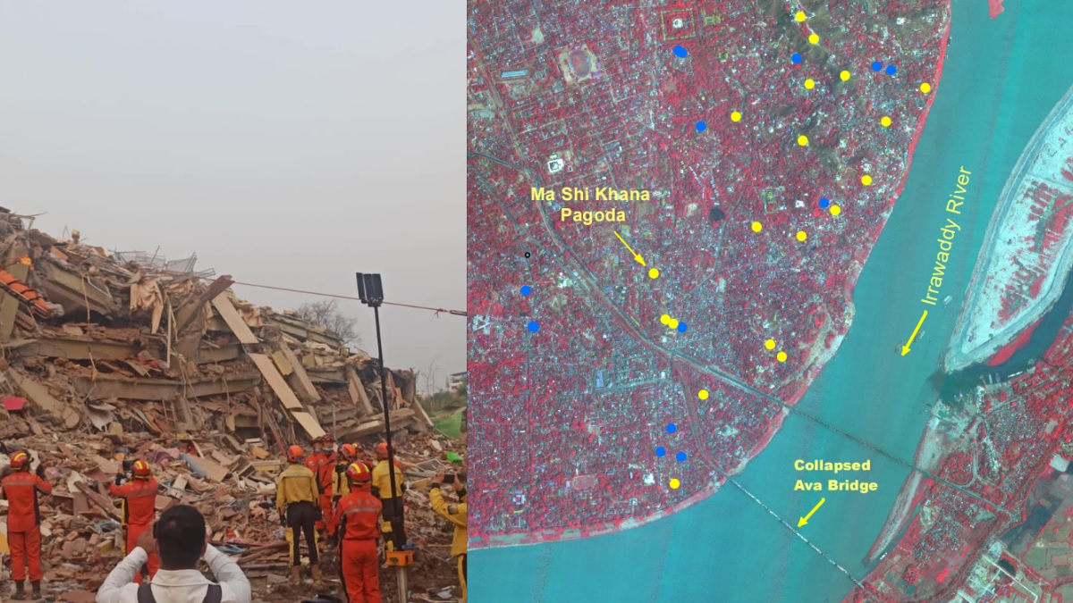
High-resolution images captured by ISRO's Cartosat-3 satellite have revealed the massive scale of the damage. One of Myanmar’s most iconic structures, the Ava Bridge, completely collapsed under the seismic force. Cultural and religious landmarks such as the Mahamuni Pagoda and several monasteries in Mandalay and Sagaing suffered extensive damage. The imagery also exposed widespread destruction of residential areas, with entire neighborhoods reduced to rubble, making relief efforts increasingly difficult.
The Myanmar military government swiftly declared a state of emergency and launched rescue operations, but the ongoing civil conflict has complicated relief efforts. With over 2,900 confirmed fatalities and thousands injured, emergency response teams are struggling against infrastructure damage, shortages of medical supplies, and logistical challenges. Volunteers from local communities have stepped in to provide aid, but the need for external assistance remains critical.
ISRO’s satellite imagery has been instrumental in disaster response, offering detailed before-and-after visuals to help authorities pinpoint the hardest-hit areas. This data has guided rescue operations, assisted in prioritizing medical aid distribution, and facilitated better coordination of relief efforts. The ability of space-based technology to provide real-time insights highlights its growing significance in disaster management worldwide.
International support has been swift, with India launching "Operation Brahma" to send medical teams, field hospitals, and essential supplies to Myanmar. China, Thailand, and the United States have also dispatched rescue personnel and aid, underlining the global solidarity in response to the tragedy.
Geologically, the earthquake occurred along the Sagaing Fault, a highly active seismic zone where the Indian and Eurasian tectonic plates collide. This incident raises serious concerns about future earthquakes in the region, emphasizing the need for improved disaster preparedness and resilient infrastructure.
As Myanmar embarks on the long road to recovery, ISRO’s contribution underscores the critical role of satellite technology in mitigating the effects of natural disasters. With continued global assistance and technological advancements, rebuilding efforts will help restore lives and communities devastated by this tragic event.
✍️ This article is written by the team of The Defense News.