CSIR-NAL’s Subscale HAP UAV Demonstrates High-Altitude Reliability in Back-to-Back Test Flights
In a significant stride toward advancing high-altitude unmanned aerial capabilities, the Council of Scientific and Industrial Research – National Aerospace Laboratories (CSIR-NAL) has successfully completed back-to-back flight demonstrations of its subscale High-Altitude Platform (HAP) Unmanned Aerial Vehicle (UAV). These flight tests were conducted from the DRDO’s Aeronautical Test Range (ATR) located at Challakere, Karnataka, which is operated by the Aeronautical Development Establishment (ADE).
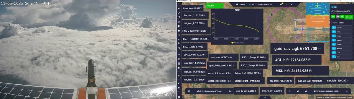
The HAP UAV reached an impressive altitude of 24,000 feet above mean sea level (AMSL) during the recent tests, reaffirming the platform's robustness, reliability, and endurance under demanding high-altitude conditions. The successful test flights mark a critical step forward in India's pursuit of persistent high-altitude surveillance and communication platforms.
Key Features of the HAP UAV
The subscale HAP UAV tested by CSIR-NAL is a scaled-down prototype of a solar-powered stratospheric aircraft envisioned to operate in the near-space region — typically between 60,000 and 70,000 feet. Though the recent tests were at 24,000 ft, they form the foundation for incremental altitude advancements toward the eventual stratospheric goals.
-
High-Endurance Design: Engineered for ultra-long endurance, the HAP UAV’s architecture incorporates lightweight composite materials and high-aspect-ratio wings for efficient lift and minimal drag at high altitudes.
-
Modular Platform: The UAV is designed as a modular testbed to validate various subsystems, including solar power management, autopilot algorithms, lightweight propulsion systems, and energy-efficient avionics.
-
Persistent Operations: Once fully developed, HAP UAVs are expected to offer weeks-long loitering capability, making them ideal for real-time communication relay, disaster monitoring, border surveillance, and maritime domain awareness.
Significance of the Back-to-Back Flights
Conducting two successive high-altitude flights in quick succession is a strong indicator of the system’s maturity. These missions validated several critical performance metrics, including:
-
Autonomous flight stability at high altitude
-
Redundant control system efficacy
-
Thermal management and energy efficiency
-
Reliable telemetry and command links at extended ranges
Such repeatable test performance at significant altitudes signals growing confidence in the platform’s viability for future full-scale development.
Strategic Implications and Future Roadmap
HAP platforms occupy a critical niche between satellites and conventional aerial systems. Unlike satellites, they can be recovered, redeployed, and maneuvered in near real-time. And unlike traditional UAVs or manned aircraft, they offer days to weeks of persistence over a region without the need for costly orbital launches.
India’s move into this space — with indigenous technologies led by public-sector R&D institutions like CSIR-NAL and DRDO — has both civilian and military applications, including:
-
24x7 communication coverage in remote areas
-
Emergency connectivity during natural disasters
-
ISR (Intelligence, Surveillance, Reconnaissance) operations over sensitive regions
-
Network extension and redundancy for armed forces
CSIR-NAL’s next step is to push the platform higher — aiming for altitudes above 30,000 ft in the coming months. The long-term goal is to transition to a solar-electric full-scale demonstrator, capable of staying aloft for weeks in the stratosphere, functioning as a pseudo-satellite or High-Altitude Pseudo-Satellite (HAPS).
Conclusion
The recent successful test flights of CSIR-NAL’s subscale HAP UAV at 24,000 ft are a notable achievement for India’s aerospace R&D ecosystem. By systematically validating key performance capabilities, the project not only highlights the country’s growing competence in autonomous aerial systems but also lays the groundwork for future stratospheric flight — a realm few nations have mastered.
As India prepares to join the select league of countries developing HAPS technologies, platforms like this could become crucial tools in achieving strategic autonomy in aerospace, communication, and surveillance infrastructure.
✍️ This article is written by the team of The Defense News.